Alcaudete
Andalusia, Spain
가입하시고, 최신 기상정보를 확인하세요!
spedmo 에 무료 가입하시고, 패러글라이딩 정보도 받아가세요.
현재 조건
알람 없음.

Aaron Hughes 비디오를 올렸습니다
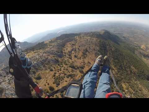
PARAGLIDING AT AHILLOS ALCAUDETE JAEN SPAIN
Video of a short soaring flight near the sunset with a little north breeze. Take off to N and S is available but only one paraglide at same time. Landing in the side ...


이륙장소의 풍향이 필요
Video of a short soaring flight near the sunset with a little north breeze. Take off to N and S is available but only one paraglide at same time. Landing in the side ...
Aaron Hughes 추가되었습니다
이륙
37.5875, -4.0484 : 1046.0 m
착륙 정보
37.5878, -4.0729 : 687.0 m
일출
8:28 오전
일몰
6:02 오후
시간대
중부유럽 표준시 (+0100)
We have launch sites within a radius of three miles for all orientations, so that if no strong wind or rain, we have secured a flight every day. Below I put a brief description of the takeoff and landing areas, with pictures of each. ---------------------------------- SIERRA AHILLOS see photos (4) Coordinates: latitude = 37.5996750 length = -4.0307188 Altitude 1373 m. SIERRA Ahillos to Alcaudete The mountain of Alcaudete Ahillos to (have to walk twenty minutes) has a vertical drop of 720m facing both North and South, when on southern weather to more than 25 km / h is to get to the landing and you'll almost all the while the wind in your face. The flight north is usually very soft, with too much height at the landings as well be you take some heat from those usually formed more by the way you can make a very entertaining flight. Alcaudete landing on whether it goes to North as the South side of the park just before the football pitch with a huge landing for anyone, about 400m long and 200m wide just outside the village. Takeoff is not suitable for beginners. -------------------------- SIERRA CARACOLERA view photos (3) Coordinates: latitude = 37.6209310 length = -4.0129548 Altitude: 1270 m. SIERRA CARACOLERA TO LAS CASILLAS TOWN For the launch of the Sierra Caracolera orientation is north marsh landing on the football field of the box or on the shore of the reservoir in case anyone does not have enough precision to land on the soccer field, the edge of swamp is very large, well enough to land with delta wings, with a drop of about 650m and a landing distance of 500m. There is also a takeoff on the E face SE to surround the mountain gives Caracolera and more than enough to reach the landing of the boxes, but to reach this you have to walk about ten minutes. They are famous here and winter flights at north and allow us to hours of flight by side with conditions very similar to a beach (very clean wind goes toward the hillside, having no natural obstacles in front). Access to off-road drive north, we should not go off easier and cleaner to inflate the front. Landing very spacious and clean perfect for novice riders. ---------------------------- CERRO GARCIA view photos (4) Coordinates: latitude = 37.6130496 length = -4.0129179 Altitude: 1195 m. FROM CERRO DE GARCÍA TO CORTIJO PORTILLO OR LAS CASILLAS TOWN In that area a departure from West and West Southwest on a hill (Cerro Garcia) between the Caracolera and Ahillos and landing on a field free of obstructions with a height of 250 m off the road rise to takeoff Portillo's farmhouse, so it can be done in several flights lazy days and more days of wind can slope. Takeoff with east behind the west to the swamp for lazy days, you reach the dam 200 meters high. Access to tourism drive off, away from the car to take off 50m. Peel school very easy, much clearance. Landing School also very clean and spacious, as seen in the photo above, perfect for novice riders. ----------------------------- MORRON see photos (3) Coordinates: latitude = 37.5914660 length = -4.0502012 Altitude: 1086 m. MORRON TO ALCAUDETE The Morrón with a drop of 400 meters from the landing to reach the park of Alcaudete (same landing from Ahillos). It has all the directions from north to south west and west to take off and easy access, which may be the most used, as it would make several flights in a short time. Just bring it we need a little cleaning up the stones in the north and south off the west and is clean. For now, take off West clean, north and southwest departures hard (only reverse inflation and slightly margin of motion). Alcaudete view photos (2) Coordinates: latitude = 37.5854654 length = -4.0734976 Altitude: 674 m. ALCAUDETE TOWN Landing zone on the side of the park just before the football field with a huge landing for anyone, about 400m long and 200m wide just outside the village. --------------------------------- CORTIJO PORTILLO view photos (3) Coordinates: latitude = 37.6068801 Length = -4.0185348 Altitude: 990 m. Unobstructed field beside the road rise to takeoff. School landing perfect for novice riders. ------------------------------ LAS CASILLAS view photos (2) Coordinates: latitude = 37.6350754 length = -3.9888207 Altitude: 531 m. Landing on the LAS CASILLAS soccer field or on the shore of the lake in case anyone does not have enough precision to land on the football field, the edge of the swamp is very large, well enough to hang gliders to land. Landing very spacious and clean perfect for novice riders. From Granada take direction to Cordoba, Alcala la Real traverse and move to Alcaudete There are no restrictions due to nearby airports There are no restrictions due to nearby airports