Son Tra Peninsula
Da Nang, Vietnam
가입하시고, 최신 기상정보를 확인하세요!
spedmo 에 무료 가입하시고, 패러글라이딩 정보도 받아가세요.
현재 조건
알람 없음.
이륙장소의 풍향이 필요
이륙
16.1179, 108.274 : 573.0 m
착륙 정보
16.1008, 108.257 : 6.0 m
일출
5:24 오전
일몰
6:22 오후
시간대
인도차이나 시간 (+0700)
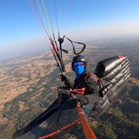
some pictures taken in recent trip to Son Tra flying site by Ha Noi Paragliding Club, http://www.flickr.com/phot...
573m ASL, can launch in 2 directions: East and South; thanks to Da Nang City support we - Ha Noi Paragliding Club - have renovated and clear a nice and wide area for preparation and take-off. The launch site is easily accessible by motorcycles and cars by newly completed asphalt pave road [see videos and pictures we made in recent trip to Son Tra flying site]. Coordinates: 16.1179 108.2738, Alt: 573 m, Timezone: ICT (UTC+7) THO QUANG beach, 2.5km below the take-off site, a long sand beach gives you plenty of spaces for nice and safe landing. Coordinates: 16.100768° 108.257243° a nice and wide asphalt paved road to the launch site is completed recently by Da Nang city, therefore the launch site can be easily accessed by motorcycles and cars. Restricted area: see picture in the link below, restricted area is marked by these 4 coordinates: 16005’00”N - 108013’40”E; 16002’50”N - 108013’40”E; 16002’50”N - 108012’25”E; 16004’18”N - 108012’25”E. - height limit: from ground level to 1500m high. - restricted time: 24/24 h of a day. http://www.danangrc.com/fo... Restricted area: see picture in the link below, restricted area is marked by these 4 coordinates: 16005’00”N - 108013’40”E; 16002’50”N - 108013’40”E; 16002’50”N - 108012’25”E; 16004’18”N - 108012’25”E. - height limit: from ground level to 1500m high. - restricted time: 24/24 h of a day. http://www.danangrc.com/fo...
아래의 회원님들이 해당 장소의 업데이트를 받고 있습니다.