La Cumbre - Colima
Colima, Mexico
가입하시고, 최신 기상정보를 확인하세요!
spedmo 에 무료 가입하시고, 패러글라이딩 정보도 받아가세요.
현재 조건
알람 없음.


이륙장소의 풍향이 필요

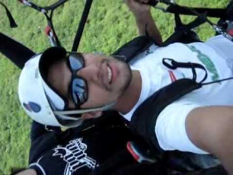
Piloto "Marcos" despegando en Parapente del cerro de la cumbre en colima México, 21 de Juio 2013.
Aaron Hughes 추가되었습니다

Despegue y Aterrizaje en parapente Tandem del Cerro de la Cumbre en Colima.
Aaron Hughes 추가되었습니다

Despegue de Gerardo Silva en el cerro de La Cumbre, Colima, Mexico.
Aaron Hughes 추가되었습니다
이륙
19.1813, -103.692 : 772.0 m
일출
6:54 오전
일몰
6:23 오후
시간대
미 중부 표준시 (-0600)
It is forbidden flying directly North of take-off, there is a national airportthere (restricted flying zone). At take-off, next to the door to the chapel, there is a printed map where one may observe the restricted zone and other details. Flying at La Cumbre has both thermal and soaring conditions. There is a range of mountains in a slight horseshoe shape that is located SE of take-off, which provides for convection, and over the valley of Piscila and Colima there are strong thermals. During December (the time of out competition) the thermal ceilings may easily reach more than 2500 m ASL (8250 feet). Ideal take-off varies between 11:00 and 14:00 hours, depending on local conditions and seasonal changes. One may fly about 85% of the year in Colima with good conditions.
Take-off is oriented SSW. Ideal take-off varies between 10:00 and 14:00 hours, depending on local conditions and seasonal changes. Take-off itself is located at the top of La Cumbre at 750 m (above sea level) 300 mts from ground.Optimal flying conditions has a breeze that comes from the sea, which is located about 50 km (31 miles) away in a straight line in a SSE direction, and the valleys in front of take-off generate optimal thermal conditions. Within visual range is a landing area next to the village of Piscila for those (piano or sled) There are many fields for landing. Cross country also have many landing fields. The old small airport is used for landing aprox Upon reaching Colima, go to the Hotel Costeño, which is out point of reunion, and is located at 1001 Carlos de la Madrid Bejar Boulevard (see the map section Ander “Lodging”). Once there, take the highway towards Jiquilpan. At the first kilometer (slightly more that half a mile) there will be a concrete police shack on your right-hand side. After another 3 kilometers (almost 2 miles) there is a small bridge overlooking the El Salado. One more kilometer (about half a mile) and on your right there is the entrance road to the village of Piscila, the landing zone in front of take-off. If you are going directly to take-off, do not turn in here, but continue on the highway. Two more kilometers (1.25 miles) alter passing the entrance to the crossroads (Jiquilpan-Piscila), there is an cobblestone road to the right of the highway (it appears just as one comes around a curve). There is a concrete shack on the left-side of this entrance and a white metal cattle-gate (usually open, but not locked if closed). There is only one cobblestone road and will lead directly to take-off. Once there one will see a large rectangular concrete structure for holding water with a chapel at the far end, topped by a statue of the Virgin. na. na.
아래의 회원님들이 해당 장소의 업데이트를 받고 있습니다.
